Drymen to Rowardennan
On leaving Drymen, you rejoin the West Highland Way as it veers away from the A811 and towards Conic Hill. The view from Conic Hill is world class, and your first taste of the epic landscapes you will experience on the West Highland Way.
Below you, stretching across the world famous Loch Lomond, are a chain of islands that mark the highland boundary fault, the literal threshold between the lowlands and the highlands of Scotland.
After tearing yourself away from the views of Loch Lomond you descend into the tiny village of Balmaha where you can enjoy a hearty meal and refreshments, or learn about the area in the National Park Visitor Centre.
For walkers looking to explore the wider area along the route, Balmaha offers access to the magical island of Inchcailloch, which also has a campsite for a unique overnight experience. Around this area, keep a look out for Ospreys too, diving and plucking fish from the surface of the loch.
This section continues along the shores of Loch Lomond through an ancient oak woodland passing three campsites; Cashel, Milarrochy and Sallochy.
Rowardennan is the starting point for those climbing Ben Lomond and is home to a popular hotel and youth hostel. You can also pick up the short 1.5km Ardess Hidden History Trail from here too.
There are seasonal waterbus services from Rowardennan to the western shores of Loch Lomond, giving the option for more choices of accommodation in a different area of the National Park.
Please be aware that upon leaving Drymen you will be entering an area where camping and firelighting management byelaws are in effect from 1st March to 30th September. During this time camping is only permitted in campsites and designated permit areas.
Please also note: there may be times (e.g. during lambing season or when works are taking place) when walkers may need to take the Creityhall Road to Milton of Buchanan and then along the B837 into Balmaha rather than the Conic Hill path.
Download here a GPS track for the Drymen to Rowardennan route section for your mobile app or GPS navigation device.
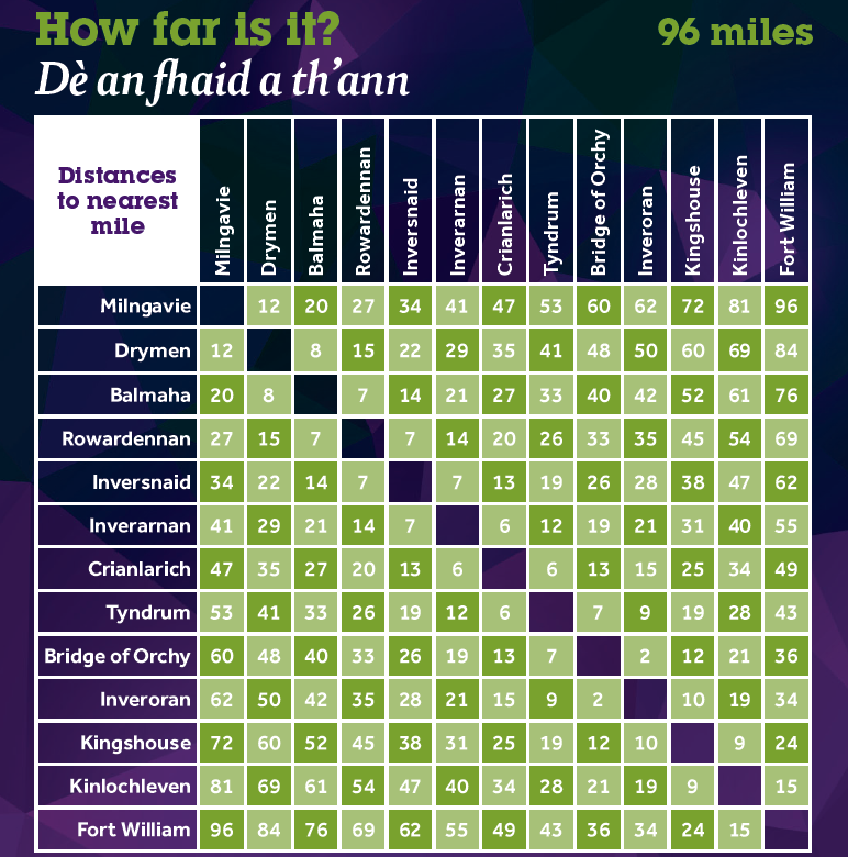
You can find out distances between various locations along the West Highland Way using the mileage chart.
Click on the symbols of the map to find out more information about each of them. This map is not intended for navigation purposes. Contains OS data © Crown copyright and database right 2017.
Elevation profile

Fast facts


Terrain
Good paths or tracks most of the way but can be twisty and undulating in some places. Some minor roadside walking but mainly lochside paths once you have left Balmaha. The only significant ascent being the section of the route over Conic Hill near Balmaha. There is a low level alternative.
Height range: 9 – 325 m
Height at start: 64 m
Height at finish: 10 m

Be aware
Upon leaving Drymen you will be entering an area where camping and firelighting management byelaws are in effect from 1st March to 30th September. During this time camping is only permitted in campsites and designated permit areas.
Please also note that dogs are not allowed in the two enclosed fields on the east approach to Conic Hill during the lambing season, even on a lead. The season normally lasts for around six weeks from mid April to the end of May. Temporary signage will be in place.

Refreshments
Drymen, Balmaha, Rowardennan

Toilets
Drymen, Balmaha, Milarrochy and Rowardennan

Places of interest
Boat trips are available from Balmaha to the island of Inchcailloch, part of Loch Lomond National Nature Reserve. The Loch Lomond & Trossachs National Park Visitor Centre at Balmaha car park is on hand to offer advice. Ben Lomond and the Ardess Hidden History Trail are accessed from Rowardennan car park.
“It has inspired me and made me want to do more long distant walking in Scotland”
Watch first-hand experience of walking the West Highland Way below.