Rowardennan to Inverarnan
This section takes in the northern, more remote section of Loch Lomond where the waters plunge to a depth of 620 feet. ** Please note: The terrain is challenging, particularly north of Inversnaid, but the sense of wildness and soaring mountains are worth the extra care and attention needed. Also, during and immediately after heavy rainfall, some burn crossings in this section may be impassable. Consider waiting until flash flooding has subsided before continuing and keep an eye on the weather.
A highlight of this section is the spectacular waterfall at Inversnaid. West Highland Way walkers can get up close as the route takes a footbridge over the waterfall as it cascades down into Loch Lomond.
The loch narrows towards its northern tip meaning that West Highland Way walkers can easily take advantage of accommodation and services on both sides of the loch. From Inversnaid there are regular waterbus services to Tarbet and Inveruglas on the western shore (look out for the iconic viewpoint that sits atop the rocks of Inveruglas). For those with accommodation at Ardlui, further north, raise the marker buoy at the pier just south of Ardleish. This will signal that you are waiting for the ferry.
Along this section you may well encounter some wild goats and catch a glimpse of our magnificent birds of prey, the Golden Eagle and the Osprey (often seen plucking fish from the surface of the loch). For expert advice pop into the Inversnaid RSPB reserve.
On arrival at Inverarnan most walkers take the opportunity to visit the renowned Drovers Inn to raise a glass with fellow West Highland Way explorers.
Please be aware that camping and firelighting management byelaws are in effect in the area from 1st March to 30th September (see the map on the right). During this time camping is only permitted in campsites and designated permit areas.
Download here a GPS track for the Rowardennan to Inverarnan route section for your mobile app or GPS navigation device.
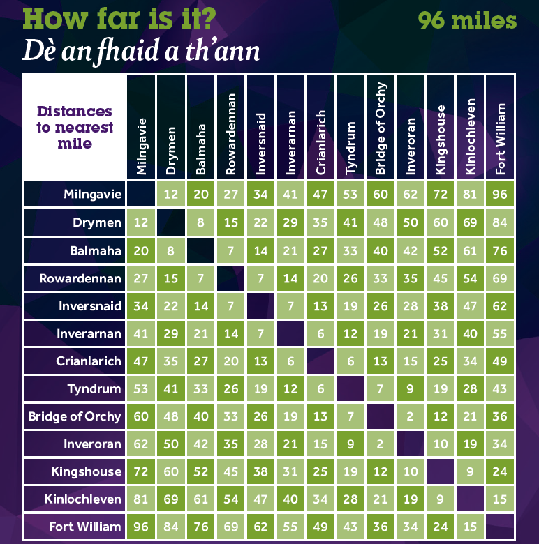
You can find out distances between various locations along the West Highland Way using the mileage chart.
Click on the symbols of the map to find out more information about each of them. This map is not intended for navigation purposes. Contains OS data © Crown copyright and database right 2017.
Elevation profile

Fast facts


Terrain
This stretch begins on forestry track following the eastern shore of Loch Lomond and becomes increasingly rougher with occasional sections of rocky path with crags and boulders. Beyond Inversnaid the route is challenging underfoot and walkers should take care to avoid twisting an ankle or tripping.
Height range: 7 – 105 m
Height at start: 10 m
Height at finish: 27 m

Be aware
Camping and firelighting management byelaws are in effect in the area from 1st March to 30th September. During this time camping is only permitted in campsites and designated permit areas.

Refreshments
Rowardennan, Inversnaid, Ardlui and Inverarnan

Toilets
Rowardennan

Stories of Rob Ruadh (Rob Roy) are closely associated with Inbhir Snàthaid (Inversnaid).
Find out more about Rob Roy’s connection with the West Highland Way here.