Inveroran to Kingshouse
From Forest Lodge, the path slowly rises up onto the edges of Rannoch Moor. This is a wild and remote section of the West Highland Way and one of the last great wildernesses of Europe. On a good day this area offers relatively straightforward walking but if the weather isn’t favourable, ensure you are wrapped up from the elements as it may be tough going across exposed ground.
Ba Bridge is halfway across the moor and an obvious rest point to take in the views. It can be bleak and beautiful at the same time depending on the conditions! A short distance after this on your left, the ruins of Ba cottage may offer some slight shelter or a lovely spot for lunch.
The undulating old military road eventually brings your march past the Glencoe Ski Centre, Black Rock Cottage and within view of one of Scotland’s most photographed mountains, Buachaille Etive Mor.
Download here a GPS track for the Inveroran to Kingshouse route section for your mobile app or GPS navigation device.
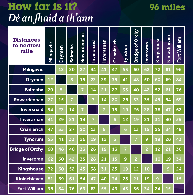
You can find out distances between various locations along the West Highland Way using the mileage chart.
Click on the symbols of the map to find out more information about each of them. This map is not intended for navigation purposes. Contains OS data © Crown copyright and database right 2017.
Elevation profile

Fast facts


Terrain
The track along the old Parliamentary Road is good but Rannoch Moor is very exposed and can be tricky in bad weather. There is no shelter on this section of the Way until reaching the Ski Centre, but in good weather this is a rewarding part of the trail with superb scenery throughout.
Height range: 168 – 446 m
Height at start: 176 m
Height at finish: 244 m

Be aware
No updates at the moment.


“It’s like coming to an oasis”
See more of the wildlife spread throughout the walk here.